|
Bài
Viết Chia Sẻ
5.
Núi
Ararat (thuộc quốc gia Thổ Nhĩ Kỳ) bến đậu
của chiếc tàu ông Noê trong thánh kinh
(*memedu@dk
đã sưu tầm được một số những di tích, lịch
sử của núi Ararat từ một số những trang web
và tài liệu khác, xin mời các bạn đọc)
- Lịch sử về chiếc tàu của ông Noê
trong thánh kinh: ...Con cái loài
người cứ tiếp tục gia tăng, nhưng tội và
gian ác cũng mỗi ngày một nhiều. Khiến Chúa
quyết định phá hủy hết những gì Ngài đã
dựng nên. Chúa phán bảo ông Noê rằng: "Hãy
đóng một con tầu lớn bằng gỗ, chỉ để một
cửa sổ và một cửa ra vào cho gia đình người
ở, vì ta chỉ thấy mình ngươi trong thời
này là người công chính, vì ta muốn phá
hủy mọi sự trên đất". Ông Noê đã đóng
tầu suốt 100 năm và không ngừng kêu gọi
dân chúng thống hối, nhưng họ chẳng thèm
nghe lời cảnh tỉnh của ông. Khi gia đình
ông Noe đã lên tầu cùng với mọi súc vật
như Chúa truyền đêm theo, Chúa đóng cửa
tầu lại. Chúa cho mưa lụt suốt 40 đêm ngày.
Nước tiếp tục dâng cao, nâng con tầu lên
khỏi ngọn núi. Hết mọi loài trên mặt đất
bị hủy diệt trừ gia đình ông Noê và mọi
sinh vật được ông đưa vào tầu. Chúa nhớ
tới gia đìnhh ông Noê và mọi sinh vật ở
trên tầu, Chúa cho nước cạn dần và không
mưa nữa. Tầu ông Noê bị mắc cạn trên ngọn
núi Ararat. Nước đã ngập lụt suốt
150 ngày trên mặt đát. Ông thả một con quạ
ra, và nó không trở lại. Ông lại thả con
bồ câu ra, nó trở về vì mặt đất còn ngập
nước. Đợi bảy ngày sau, ông Noê lại thả
con bồ câu ra, nhưng nó không trở về nữa,
ông biết là mặt đất đã khô ráo. Khi mặt
đất hoàn toàn khô ráo, gia đình ông Noê
cùng tất cả sinh vật ra khỏi tầu. Ông lập
một bàn thờ và dâng lễ tạ ơn Chúa. Chúa
chúc phúc cho Noê và Ngài hứa sẽ không phá
hủy trái đất như vậy nữa. Ngài phán: "Cầu
vồng trên trời kia là giao ước của Ta với
trái đất"...
- Núi Ararat ngày hôm nay:
Mount Ararat 1999 - Courtesy Rob Michelson
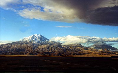
Mount Ararat is located in Eastern Turkey
on the borders of Iran, Armenia (formerly
U.S.S.R.), and Nachivan. This volcanic
mountain rises 5,165 meters or 16,945
feet high above the plains and is the
highest location in the ancient kingdom
of Urartu, a region which covered thousands
of square miles. Ararat is the bastardized
name of Urartu from the Hebrew Torah written
by Moses (c. 1450 BC) which only included
the consonants "rrt". However,
the translators of the Bible replaced
the "rrt" with the later name,
"Ararat." The Assyrians wrote
about battles against the Urartian tribes
from the thirteenth century BC until the
sixth century BC when Urartu was destroyed
by the Medes. The name Urartu then vanished
from history and was replaced by Ararat
and Armenia in the vicinity as well as
in Bible translations in English, etc.
As history went on in the first and second
millenia AD, the mountain became known
as Ararat and the region as Armenia. Many
people believe that Mount Ararat is the
place where Noah's Ark landed but the
Bible does not state this. It simply says
that the boat landed in the Urartian mountains,
of which there are hundreds, although
Ararat is the highest. Since Mount Ararat
is the highest location in Urartu, some
people throughout history have jumped
to the unproven conclusion that it was
the landing place and promoted that concept
as a regional tradition.
Mount Ararat may be the largest single-mass
or volume mountain in the world as it
is huge (one really has to see it in person
to appreciate its immensity) and rises
to 17,000 feet from the plains surrounding
it at 2,000-3,000 feet while most other
large mountains are in a mountain range
with less differential and base circumference.
Ararat has only a few native trees growing
on it in Ahora village and several small
forests on Little Ararat. Views differ
as to whether Ararat formed much of its
size after the flood (post-flood) or during
the flood as some geologists like Seventh
Day Adventist Clifford Burdick Ph.D. have
claimed to find pillow lava (lava spewed
into water) around the 14,000-foot level.
Some geologists claim that cylindrical
mountains like Little Ararat show that
it is a post-flood mountain. There are
also claims of fossils and sedimentary
layers on Greater Ararat but these claims
have not been backed up with evidence
as of this date although there are fossils
near Ararat. From 14,000 feet to 17,000
feet, much of the lava is covered by an
ice cap which is about 17 square miles
in size and is up to 300 feet deep. As
computed by ArcImaging, the coordinates
that cover the ice cap area on Mount Ararat
are N 39 degrees 41' to N 39 degrees 44',
E 44 degrees 15' 30" to E 44 degrees
19' 30". The area of this rectangle
is about 31.6 square kilometers.
Since the upper reaches of this volcanic
mountain are covered with broken lava
rock everywhere and are currently extremely
difficult to ascend or descend, its present
state makes it a poor location for Noah's
Ark to land and for all the animals to
easily descend. Yet, Mount Ararat has
the bulk of the purported eyewitnesses
of the boat-like structure, especially
since 1850. These "alleged"
eyewitnesses are the only reason why the
search should continue on the mountain.
Given the extensive research which has
taken place on Mount Ararat, it seems
fair to say that if Noah's Ark ever survived
into modern times and is somewhere on
Ararat, there are few new places remaining
on the mountain to search. There have
been many expeditions, accounts, alleged
sightings, anomalies, and claims of discovery
involving Mount Ararat. What is lacking
is any scientific evidence or photo that
shows that Noah's Ark exists today. However,
one should also consider the possibility
that Noah's Ark landed on Mount Ararat
and was subsequently destroyed, which
is the possibility alluded to in the article
Even If Noah’s Ark Is Not Proven, Noah’s
Ark Still Could Have Landed On Mount Ararat.
Given all the ground and aerial expeditions
(and one with sophisticated mapping capabilities),
one should surmise that if the remains
of Noah's Ark are indeed on Mount Ararat,
they are not in plain view; if the boat
is there, it must be buried. There have
been 2 attempts that used sub-surface
Radar (Ground Penetrating Radar - GPR)
technology on Mount Ararat to look under
the ice. The 1988 Willis expedition and
the 1989 Aaron/Garbe/Corbin expedition
used GPR. The 1988 Willis expedition successfully
surveyed the eastern summit plateau and
the saddle area between the two peaks,
concluding there were no Ark remains under
the ice. The 1989 expedition was not as
successful as the preceding year, where
a less-capable GPR system was used in
temperate (melting) ice cap conditions
on the western plateau of Mount Ararat.
However, they were able to determine the
ice depth on the western plateau and scale
the size of the Ark.
If the remains of Noah's Ark were in
moving ice on Mount Ararat (there is only
one legitimate glacier, the Black Glacier,
though there are other moving ice flows
like the so-called Parrot Glacier), the
Ark would have been ground to bits. ArcImaging
contends that until the entire mountain
has been adequately "sub-surface"
surveyed using the latest remote sensing
technology, some people such as the alleged
eyewitnesses contended that the Ararat
ice cap contains the remains of Noah's
Ark since about 90% of the supposed eyewitnesses
claim that the boat was sticking out of
the ice even though the explorers over
the past 50 years did not see the same
boat-like structure.
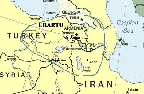
Ancient Kingdom
of Urartu
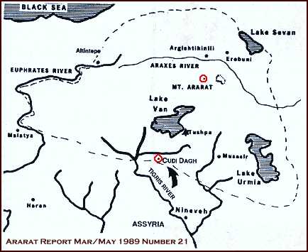
The Bible's account of Noah, the ark, and
the Genesis flood states that the ark came
to rest on the "mountains of rrt"
where "rrt" has been translated
"Urartu" or later "Ararat"
during Armenian times. At the beginning
of the Christian era, Ararat (another version
of the Hebrew "rrt" - no vowels
in the original Hebrew text of Genesis")
was only a northerly subdivision of Armenia
near the Araxes river. During the time of
the Old Testament though, the Urartian region
was much more extensive (as shown on the
map above). From Assyrian texts, Urartu
is known to have existed from about the
late 13th century BC to the 9th century
BC as a loose federation of tribes. However,
if one takes a conservative view of Moses
writing Genesis in the 15th century BC rather
than the 13th century BC, then Urartu would
have been known even in that era. The Urartian
Kingdom existed from the 9th century BC
until the 6th century BC when it was destroyed
by the Medes and vanished from history,
only to be rediscovered in the archaeology
of the late 1800s and early 1900s. Thus
there exists the possibility of a mis-interpretation
of Genesis by post-Christian writers and
Armenians restricting the Ark's landfall
to the smaller Araxes valley area including
Mount Ararat rather than the larger Urartian
region or "mountains of Urartu"
as described by Moses in Genesis. However,
some of this is speculation since there
are no cross-references in 15th century
BC writing so no one really knows exactly
where Moses was referring to when he stated
that the ark came to rest on the "mountains
of rrt".
For a photo album of Urartu, visit the
ArcImaging Urartu Photo Album.
- Ông Henri Nissen (người Đan Mạch),
mặc dù là một ký giả, nhưng ông đã bỏ ra
nhiều năm để nghiên cứu về sự hiện hửu lịch
sử ông Noê và chiếc tầu của ông. Henri Nissen
đã viết thành một cuốn sách dầy 319 trang
bằng Đan ngữ và Anh Ngữ. Các bạn có thể
vào trang web nầy http://hosianna.dk/product.asp?product=70
để đặt mua sách hoặc DVD. Các bạn có thể
bấm vào đây để xem
giới thiệu sách (bằng tiếng Đan Mạch).
|